![]() Where present on a page, click for popup footnote.
Where present on a page, click for popup footnote.
The Diez's (and Reister's) eventually accumulated some 2400 acres through Federal land patents in Custer and Huerfano Counties. The original Homestead Patents appear to have been located in Township 23-S Range 72-W. Additional Patents were eventually acquired to the east in T23S70W and T24S70W, with a few scattered plots elsewhere.
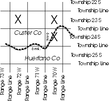 |
| Location of major Diez Patents (X) |
| Table of Diez family Land Patents. |
| Patents in Township 23-S Range 72-W |
| Patents in Townships 23-S & 24-S Range 72-W |
A Township is a square region 6 miles on each side and
is bounded on the north and south by Township Lines and on the east and
west by Range Lines. Unlike in the Northeast where townships have
important political and governmental significance, townships in much
of the Midwest and West often do not have any other significance than as
a surveying convenience.
Townships, rather than being individually numbered or named, are
referenced relative to a Baseline (e.g. Township 23 S meaning the 23rd
Township South of the baseline) in a specified column (Range) of
Townships. The column is specified relative to a Principal Meridian
(e.g. Range 70 W, meaning the 70th Range West of the Principal Meridian
defined for that region) -- therefore the Township's reference or
"name" T23S70W. While in some jurisdictions, an actual name may be
assigned to the township, and there may be some political or
governmental significance, this usually is minor -- the principal
intra-state governance unit being the county or incorporated cities and
villages.
See Land Descriptions, Bureau of Land Management, and Indiana Land Surveys, Their Development and Uses, for a detailed discussion of western lands, townships and sections.
In the part of Colorado of interest, the Township Lines are relative to a Baseline at the 40th Parallel which runs east-west near Boulder, CO (and is the border between Kansas and Nebraska), and the Range Lines are relative to the Sixth Principal Meridian (which passes through central Kansas).
See Public Land Survey System, Kansas Society of Land Surveyors for a discussion on how these lines were established.
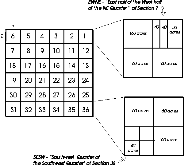
Each Township is divided into 36 square Sections. Each Section is 1 square mile, which is 640 acres. The 36 Sections of each Township are numbered as below.
Each Section was further subdivided into halves and quarters, repeatedly, until the parcel of land was accurately described. Without the use of Fractional Sections, Blocks, or Lots (in the case of uneven parcels of land), Aliquot Parts were used to represent the exact subdivision of the section of land. Halves of a Section (or subdivision thereof) are represented as N, S, E, and W (such as "the north half of section 5"). Quarters of a Section (or subdivision thereof) are represented as NW, SW, NE, and SE (such as "the northwest quarter of section 5"). Sometimes, several Aliquot Parts are required to accurately describe a parcel of land. For example, "ESW" denotes the "east half of the southwest quarter" containing 80 acres and "SWNENE" denotes the "southwest quarter of the northeast quarter of the northeast quarter" containing 10 acres.
![]() © 2011 John B. Deitz
© 2011 John B. Deitz
This page last updated: